Learn the importance of an erosion control plan, who is responsible for it, its essential components, and how to create your own erosion and sediment control plan. An effective erosion control plan is vital for managing soil displacement during construction. It ensures compliance with environmental regulations, preventing sediment runoff. Whether for a residential or commercial project, understanding the topographic service and utility layout is essential to the planning process.
What is an Erosion Control Plan?
An erosion control plan is a tailored strategy that identifies erosion risks for a specific site and outlines measures to minimize erosion and sedimentation during construction. This plan is crucial to maintaining environmental integrity throughout a project. Without it, the project could face environmental fines and delays. A well-structured plan ensures that all potential risks are addressed early on, providing clarity on the necessary steps to safeguard the environment. For effective planning, it’s essential to include detailed site maps, including utility layout and concrete layout, to ensure a seamless process.
Construction activities often disturb the soil, making it more susceptible to erosion by wind and water, which can lead to sedimentation. Eroded soil can result in several issues, such as water quality degradation and diminished crop growth in surrounding areas. This soil displacement can cause a negative impact on local ecosystems, harming wildlife habitats and water sources. It’s important to identify these risks early and develop strategies to prevent long-term damage. Using CAD files and accurate topographic services allows for precise planning and better mitigation of erosion risks.
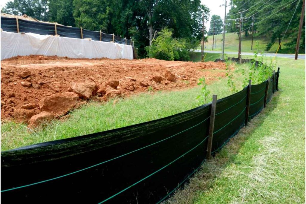
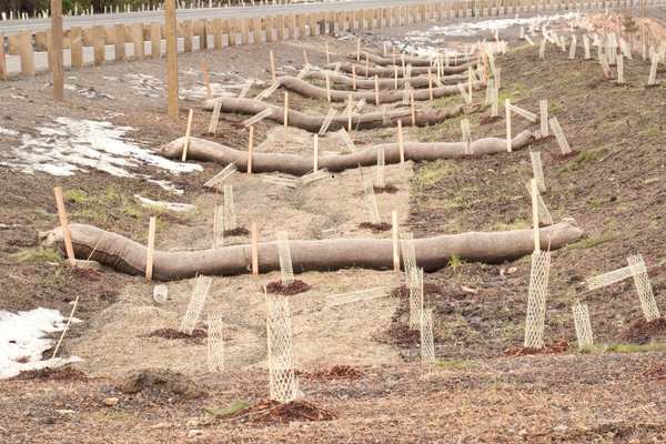
A detailed erosion and sediment control plan addresses these risks, specifying necessary actions to mitigate erosion. It outlines the best practices for reducing soil disruption and implementing sedimentation control methods. This plan should include a clear demolition layout, utility layout, and concrete layout for effective site management. Additionally, specific erosion control techniques like silt fences, sediment basins, and erosion control blankets should be highlighted. Proper planning ensures that your project meets legal requirements while safeguarding the environment. Make sure that all components, including the topographic service, are incorporated for full-scale control.
What Does Erosion Control Plan Involve?
Erosion occurs when natural forces, such as wind and water, or human activities, like construction, wear down the ground. This process often leads to the loss of moisture in the soil, negatively affecting crops and vegetation. Erosion also exposes the subsoil, which lacks the nutrients of the topsoil, resulting in long-term environmental damage. Effective erosion control strategies are essential to prevent these issues, and using accurate tools like CAD files and topographic services can help create a well-planned control strategy.
Human activities, such as land development, construction, and improper land management, significantly contribute to erosion. To mitigate these effects, it’s crucial to implement erosion and sediment control measures that reduce soil displacement. Proper erosion control can prevent water contamination, protect plant life, and ensure the long-term health of the environment. A clear utility layout and concrete layout in the control plan are essential in ensuring all aspects of construction are considered, minimizing the risk of erosion.
Erosion and sediment control is designed to limit erosion and sediment movement across a site. This process safeguards water quality and prevents sediment from harming natural habitats. Implementing strategies such as silt fences, sediment basins, and other erosion prevention techniques ensures that construction activities do not negatively affect the environment. A comprehensive demolition layout and building layout further streamline the process, integrating erosion control directly into the construction plan for seamless implementation.
Different erosion control methods are suited to specific sites, with tailored solutions based on the project’s needs. Local authorities often require a detailed erosion and sediment control plan before construction begins, ensuring all necessary measures are in place. Including accurate CAD files and utility layouts in the plan helps create an effective, site-specific strategy to manage erosion and sedimentation.
When is an Erosion Control Plan Needed by Organizations?
The need for an erosion and sediment control plan can differ depending on local regulations, but it’s vital for any organization to implement effective erosion and sedimentation controls before starting a project. Even if not legally required, taking these precautions helps maintain the project’s safety and long-term sustainability. Including a detailed building layout and utility layout in the plan ensures that all construction elements are properly managed, reducing environmental impact.
In some areas, erosion and sediment control practices may be necessary without a formal plan, though large construction projects that disturb the land generally require one before work can proceed. This ensures that the project won’t negatively affect the environment or surrounding communities. Including a comprehensive demolition layout along with erosion control measures guarantees that all construction phases are covered and well-coordinated, preventing unnecessary environmental damage.
Any project that alters or disturbs the ground, whether through excavation, grading, or landscaping, will typically require an erosion and sediment control plan. Erosion and sedimentation can severely impact water quality and local ecosystems, making it essential to have preventive measures in place. A well-structured control plan, supported by topographic services and CAD files, helps minimize these risks and ensures the project adheres to all necessary regulations, protecting both the environment and local communities.
What Makes It Crucial?
Erosion is a natural process that gradually wears down the earth, primarily caused by water and wind. However, human activities can accelerate this process, and when left unchecked, erosion can have severe consequences for businesses, society, and the environment. Effective erosion control is crucial in mitigating these impacts, particularly in areas where construction or land development is taking place.
A clear example of erosion’s impact is on agriculture. Crops, essential for sustaining human populations, require specific soil conditions to thrive. This includes not only the chemical composition but also the water levels underground. When erosion and sedimentation occur, these factors can be altered, affecting soil quality and moisture retention. As a result, crop yields can decline, leading to broader economic and societal consequences.
Erosion and sediment control plans are not only required for certain projects but are also necessary for maintaining environmental safety. A well-crafted control plan shows that the organization has evaluated the project’s environmental effects and implemented strategies to minimize harm. This proactive approach preserves soil health, protects water quality, and keeps the surrounding ecosystem intact throughout the project.

Essential Elements In An Erosion Control Plan
The components required in an erosion and sediment control plan can vary based on the project’s location and scale. However, there are several common elements typically included in most plans. These components are essential for ensuring the effectiveness of the control measures and minimizing environmental impact.
Map of the Site
A detailed location map of the project site is a crucial component of an erosion and sediment control plan. These maps should clearly indicate the site’s proximity to bodies of water, roads, access points, and other significant features. Such maps help identify vulnerable areas and guide the placement of erosion control measures, like silt fences or sediment basins, to protect the environment. Additionally, mapping out key features such as elevation changes and existing vegetation allows for a better understanding of natural drainage patterns. This thorough assessment enables more effective planning and mitigation strategies to reduce erosion risks during construction.
Existing Conditions of the Site
This component includes a soil map and an assessment of the current soil conditions at the project site. The soil map should outline the different soil types, their properties, and any potential issues related to erosion or drainage. The site conditions must reflect all the grading details and natural features of the land before the project begins. This information is essential for understanding how the soil will respond to construction activities and helps determine the appropriate erosion control measures. By analyzing soil characteristics, such as permeability and stability, the plan can identify areas more prone to erosion and provide targeted solutions to protect the site.
Grading and Slope Plan
This section outlines the proposed finished contours of the land after grading and construction. It details how the land will be shaped and the elevation changes throughout the project. A timetable should also be included, highlighting each phase and its potential impact on the soil. The grading plan must also specify control measures for each phase to minimize exposed soil. These measures may include temporary ground covers, erosion barriers, or sediment traps, which help reduce the risk of erosion during construction. Proper planning ensures that erosion is managed efficiently, safeguarding the environment throughout the project’s timeline.
Timeline and Schedule
This section of the plan outlines the specific erosion and sediment control measures that will be implemented throughout the project. These measures are designed to minimize soil erosion and manage sediment movement during construction. The grading plan serves as the foundation for this strategy, ensuring that the control measures align with the planned land contours and soil conditions. IIn many cases, the erosion and sediment control plan combines with the grading plan for a more cohesive approach. This integration improves coordination, ensuring effective implementation of control measures like silt fences, sediment basins, and erosion control blankets throughout the project.
Comprehensive Narrative Report
A comprehensive erosion and sediment control plan includes a detailed narrative for each project phase, outlining specific control measures. This report clearly explains how erosion and sedimentation will be managed at each stage. It helps anyone reviewing the plan understand the strategies that will be used to minimize environmental impact. The narrative should cover everything from initial soil stabilization methods to ongoing monitoring and maintenance efforts, ensuring that control measures are adapted to the evolving needs of the project. This level of detail ensures transparency and demonstrates a proactive approach to environmental protection throughout the construction process.
Developing an Erosion Control Plan
Erosion and sediment control plans are vital for environmental protection and often required for certain projects. However, creating a comprehensive plan can be challenging, especially while managing other project aspects.
Using an erosion and sediment control plan template can simplify the process. With a template, organizations save time and effort by using pre-outlined components. The team only needs to fill in project-specific details, streamlining the process.
For greater convenience, companies like Precision Site Control offer specialized services to help organizations create and implement erosion and sediment control plans. Their tools and expertise simplify the process, allowing teams to focus on other project aspects. These services support erosion control while boosting productivity, ensuring projects are completed on time and within environmental guidelines.
Why Opt for Precision Control Site?
Here are some of the standout features of Precision Site Control that can greatly enhance the process of creating an erosion and sediment control plan:
Comprehensive checklist templates ensure teams address every key aspect of the control plan, minimizing the risk of missing details.
Real-Time Team Updates with Heads Up: This tool keeps all team members informed and promotes clear, continuous communication, ensuring everyone stays aligned throughout the project.
Automated Report Generation: Precision Site Control can generate detailed reports with essential data, such as soil conditions and grading details, aiding in the creation of a well-informed control plan.
Employee Training Resources: The platform provides training to employees on best practices for erosion and sediment control and safety protocols, ensuring that all workers are knowledgeable and well-prepared.
Efficient Asset Tracking and Management: With this feature, teams can monitor and manage assets in real-time, providing the flexibility to oversee resources from anywhere and ensuring proper allocation throughout the project.
Conclusion
An erosion control plan is essential for managing soil displacement during construction, preventing environmental damage such as sediment runoff. This plan outlines specific actions to minimize erosion risks, including site maps, grading details, and erosion control measures like silt fences and sediment basins. It ensures the project complies with environmental regulations and protects local ecosystems.
Using templates or professional services like Precision Site Control can streamline the planning process. These resources help track soil conditions, grading, and construction phases, ensuring efficiency and environmental protection. A well-crafted plan is crucial for safeguarding both the environment and the success of construction projects.
FAQs
How do weather conditions affect erosion control?
Heavy rain and wind can speed up soil erosion, requiring additional planning for protection.
Can erosion control measures be reused?
Yes, many methods like silt fences can be reused on other projects.
How often should the erosion control plan be reviewed?
Regular reviews, especially after weather events, ensure ongoing effectiveness.
What are common mistakes in erosion control planning?
Errors include poor mapping, neglecting local regulations, and ignoring seasonal changes.
What tools assess erosion risks?
Topographic surveys, soil analysis, and CAD mapping help identify risks before construction.
Users Also Say
A_*****Ho****an
“Ask the city if they have any standard plans so you can pull notes etc. Other than that it’s mostly about keeping the sediment on site. If you have CMU property walls it’s pretty straight forward. You need to place sandbags along the perimeter of the property but can omit In areas with block walls.”
Id***on
“A quick Google search will put you in touch with a ton of providers for swppp services. They are very affordable and will save you the hassle of trying to take on yourself.”
P***8
“Erosion control is a big source of pollution prevention.”