
If you’re looking to develop or sell your residential or commercial property, you’re likely asking how long a land survey takes. Understanding the purpose is key before you begin. A land survey provides crucial information about boundaries, elevations, and structures. Typically, a land survey for boundary identification includes a topographic survey, utility layout, and concrete layout.
Many clients also request an erosion control plan or demolition layout to ensure proper land development. It’s important to know that the timeline depends on factors like property size, complexity, and available CAD files. Having all these details upfront helps expedite the process.

What Is A Land Survey?
Land surveying provides essential details about your property and includes various types of surveys. The most common is the boundary survey, which outlines the property’s boundaries and associated assets. This survey is often combined with other services, like utility layouts and concrete layouts, to give a complete view. For larger projects, a topographic survey might also be needed, showing the land’s elevation and contours.
In addition to mapping boundaries, a demolition layout and erosion control plan can be crucial for development. With CAD files included, you get precise and organized data for better planning and execution.
Why is Land Survey Necessary?
A boundary survey provides an accurate map of your property’s boundaries and key features, offering a thorough evaluation before beginning construction. This survey is critical for understanding land elevation and layout, ensuring your project progresses smoothly without legal or zoning issues. It also helps assess the land’s value, providing a clear picture of its potential. Incorporating additional details like a demolition layout or erosion control plan can enhance planning, making sure the entire development process is efficiently managed.
Boundary surveys are vital when selling property, as they offer legal certainty and full disclosure to potential buyers. These surveys clearly define the property lines, reducing the risk of future disputes and boosting buyer confidence. A survey before selling ensures you can accurately represent the property’s boundaries, avoiding complications related to utility placement or building over the line. Full transparency benefits both the seller and the buyer, fostering a smoother transaction.
Having a property survey before selling helps eliminate discrepancies that could affect the property’s value or result in legal disputes down the road. It offers both parties peace of mind with clear documentation of the property’s exact dimensions. Additionally, if you plan to build, a survey ensures you remain within the legal boundaries of your land and adhere to zoning laws. With the right CAD files and utility layout, you’ll have the critical information needed for an efficient and precise construction plan.
How Long Does a Land Survey Take?
Property surveys can vary in duration based on factors such as property size, features, and location. Typically, a boundary survey can take anywhere from two to ten business days to complete. It’s wise to plan for at least ten business days to ensure any unexpected delays are accounted for. Surveying larger or more complex properties, especially those requiring additional details like utility layout or topographic services, may require more time to finalize.
Boundary property surveys are usually conducted in a series of well-defined steps.
Research
Your boundary land surveyors will begin by examining your property’s historical records, deeds, and prior surveys. This thorough review helps them collect all necessary information regarding the land’s boundaries and ownership history. They will meticulously verify these documents to ensure the data is current and consistent. This step is essential to uncover any discrepancies or errors in previous surveys that could impact the accuracy of the current one. By addressing any inconsistencies early on, you can avoid potential financial or legal issues down the line.
Beyond reviewing historical documents, the surveyors will also integrate additional details, such as utility layout, topographic service, and other key components. This holistic approach ensures that every aspect of the property is accurately documented, providing you with a comprehensive understanding of the land. Whether you’re planning a new construction, setting up erosion control, or preparing for zoning compliance, having all this information up front ensures smoother planning and development. With complete data on hand, you can confidently move forward with your project while avoiding costly mistakes.
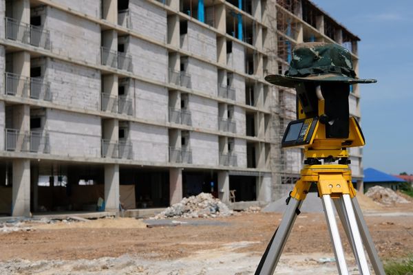
Field Surveying
The land surveyors will visit your property to take accurate measurements and create a detailed map of the land. This phase requires the use of advanced equipment such as GPS systems, total stations, and theodolites, all designed to gather precise data on boundary markers, terrain features, and existing structures. The surveyors will meticulously measure every aspect of the land, ensuring no detail is overlooked and all boundaries are clearly defined.
By utilizing this specialized technology, the surveyors are able to produce highly accurate measurements that are critical for any future development or construction. Whether you’re planning for a new building layout, utility placement, or an erosion control plan, these accurate data points provide a solid foundation for your project. This process ensures that the land is mapped correctly, avoiding any potential conflicts with zoning laws, boundary disputes, or other issues that may arise during development. With these reliable measurements in hand, you can proceed with confidence, knowing that the information is precise and comprehensive.
Data Evaluation
Once the field data is gathered, the team of land surveyors will analyze it carefully to ensure accuracy. They will compare the measurements and features collected on-site against the historical records, deeds, and any previous surveys to identify any discrepancies. This comparison is crucial for confirming the precise boundaries of your property and ensuring everything aligns correctly with legal documents.
The surveyors will meticulously review the data to pinpoint your property’s exact boundary lines, taking into account any natural landmarks, previous boundaries, or other features that could impact the survey. This step is essential for creating an accurate and legally binding boundary survey. By verifying and cross-checking the data, they can provide you with a reliable map that is essential for future development, whether it’s for building layout, utility placement, or ensuring compliance with local zoning regulations.
Map Development
Once the data is confirmed to be accurate, the team will proceed to create a detailed survey map, also known as a plat, that clearly shows your property’s boundaries and dimensions. This map serves as a precise representation of your land, marking the exact limits and layout. It will typically highlight key features such as existing structures, roads, easements, and any notable natural features like rivers or hills.
In addition to outlining property lines, the survey map may include other relevant information, such as utility layouts, zoning boundaries, and topographic details. This comprehensive map provides a clear visual representation of your land, which is crucial for both legal purposes and planning future projects. Whether you’re preparing for construction, selling, or resolving boundary disputes, this map will be an essential tool for ensuring everything aligns with your property’s true dimensions and features.
Concluding Report
After compiling all the gathered data, your land surveyors will prepare a final survey report that includes the detailed findings and survey map. This comprehensive report will include everything from boundary lines and measurements to any relevant features or structures on your property. It serves as an official document that confirms the exact dimensions and layout of your land, ensuring it’s ready for any development or legal purposes.
Once completed, the final survey report will be provided to you, the client. This document is crucial for various steps in the development process, whether you’re building, selling, or resolving boundary disputes. With the survey report in hand, you’ll have an authoritative record of your property’s details, which can be used for zoning approvals, utility planning, and other critical stages of your project.
Factors That Can Delay Your Boundary Survey
There are several factors that can delay the completion of a boundary survey. For example, if property deeds have conflicting information, surveyors may need extra time to resolve discrepancies and determine accurate boundaries. Weather conditions can also affect the timeline. Heavy rain or flooding, particularly on prone properties, can delay the survey. Similarly, high winds or extreme weather may prevent equipment setup, causing further delays. Legal disputes related to property ownership or boundaries may also hinder progress. To avoid such issues, it’s advisable to schedule your property survey well in advance, especially if you’re planning to build or sell your land.
If you’re opting for a property survey that isn’t a boundary survey, the completion time can vary based on the specific requirements. For example, topographic surveys, utility layouts, or demolition layouts may require different amounts of time depending on the complexity and scale of the property. Each type of survey has its own unique needs and challenges, which could affect how long it takes to complete.
The Best Dallas/Fort Worth Texas Land Surveyors
Now that you have a clearer understanding of how long a property survey might take, when it’s needed, and the process involved, it’s time to choose the right team for your project. Selecting an experienced team ensures accurate results and smooth execution, so you can confidently move forward with your plans.
If you’re in the Dallas/Fort Worth area, our team at Precision Site Control is the perfect fit for your land surveying needs. We specialize in handling the unique challenges of surveying in this region, where expertise in high elevations is essential. Whether you need a boundary survey, topographic service, or utility layout, our skilled team can get the job done right. Call us today at (817) 994-9002 or contact us online to schedule your land survey.
Conclusion
The duration of a land survey can vary significantly depending on several factors. Typically, a boundary survey might take anywhere from two to ten business days. The complexity of the property, its size, and specific features like utilities and topography can extend this timeline. It’s also important to consider additional requirements, like erosion control plans or demolition layouts. These can complicate and lengthen the process.
FAQs
Can weather conditions affect the timeline of my land survey?
Yes, weather like heavy rain or high winds can delay the survey process, especially if the property is prone to flooding.
What happens if there are discrepancies in the property deed during the survey?
Surveyors will investigate and resolve discrepancies, which may take extra time to ensure accuracy.
How do I prepare for a land survey on my property?
Providing clear access to your property, gathering any available historical records, and ensuring no obstructions can help speed up the process.
Can the size of my property affect how long the survey takes?
Yes, larger or more complex properties typically require more time for surveyors to measure, map, and evaluate.
How can I avoid delays in my land survey?
Schedule the survey well in advance, provide accurate historical information, and ensure the property is easily accessible for surveyors.
Users Also Say
Ni***um****gs
“The other people are living in a fantasy world. If a surveyor is starting from scratch you’re talking at least a month, probably 2. If they’re updating an existing one, MAYBE 2-3 weeks”
a**mm****tt
“Sometimes a month, sometimes a year. There’s so many variables involved it’s hard to give an exact average. It’s not like getting a deck built.”
la*****11
“gotten survey done twice, once was a new survey and the other time was an update, both took roughly 2 weeks”